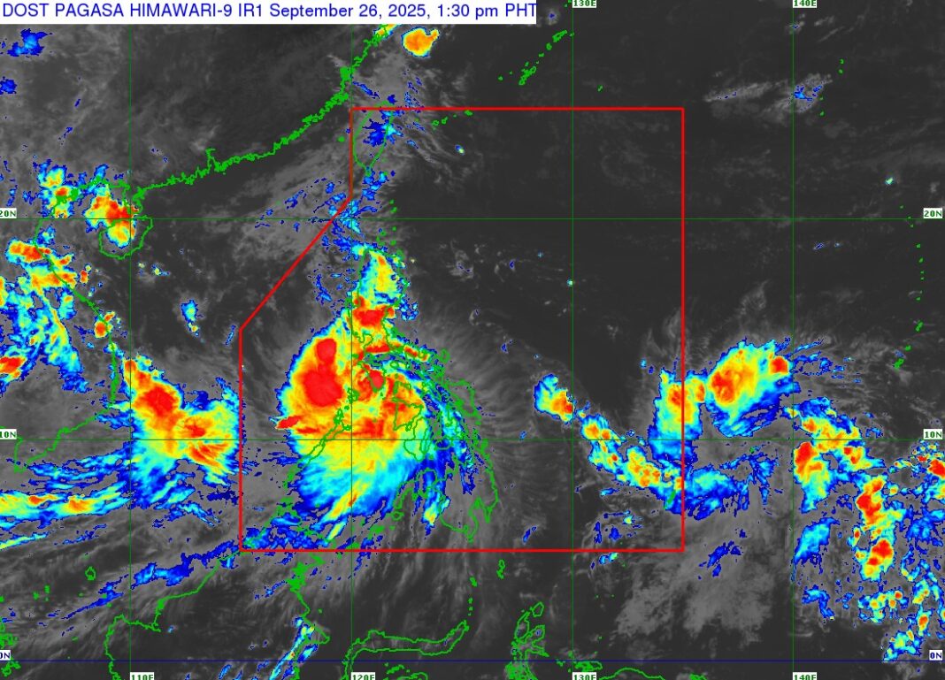
AS of approximately 1:00 PM today, the center of Severe Tropical Storm Opong made landfall over Mansalay, Oriental Mindoro. Based on all available data, including readings from the Daet Doppler Weather Radar, the storm’s center was located in the vicinity of San Jose, Occidental Mindoro at coordinates 12.4°N, 121.1°E.
Severe Tropical Storm Opong is currently packing maximum sustained winds of 110 km/h near the center, with gusts of up to 150 km/h, and a central pressure of 985 hPa. The system is tracking westward at a speed of 20 km/h, with strong to storm-force winds extending outward up to 460 km from the center.
TROPICAL CYCLONE WIND SIGNALS CURRENTLY IN EFFECT:
Tropical Cyclone Wind Signal (TCWS) No. 3
- Wind Threat: Storm-force winds (89–117 km/h) expected within the next 18 hours
- Threat Level: Moderate to significant threat to life and property
Areas under TCWS No. 3:
Luzon:
- Batangas
- Marinduque
- Romblon
- Occidental Mindoro
- Oriental Mindoro
- Calamian Group of Islands
Visayas:
- Northwestern Aklan (Malay, Nabas, Buruanga)
- Caluya Islands
Tropical Cyclone Wind Signal (TCWS) No. 2
- Wind Threat: Gale-force winds (62–88 km/h) expected within the next 24 hours
- Threat Level: Minor to moderate threat to life and property
Areas under TCWS No. 2:
Luzon:
- Southern Zambales (San Marcelino, Subic, Olongapo City, Castillejos, San Antonio, San Narciso, San Felipe)
- Bataan
- Southern Pampanga (including Porac, Santa Rita, Guagua, and others)
- Southern Bulacan (including San Jose del Monte, Meycauayan, Malolos, and others)
- Metro Manila
- Rizal
- Cavite
- Laguna
- Central and Southern Quezon (including Lucena City, Pagbilao, Tayabas, and others)
- Cuyo Islands
- Northern Palawan (El Nido, Taytay, Araceli)
- Western Masbate (Aroroy, Balud, Mandaon, etc.), including Burias Island
Visayas:
- Northern Antique (Libertad, Pandan, Sebaste, Culasi, etc.)
- Rest of Aklan
- Capiz
- Northern Iloilo (Estancia, Carles, Ajuy, Passi City, etc.)
Tropical Cyclone Wind Signal (TCWS) No. 1
- Wind Threat: Strong winds (39–61 km/h) expected within the next 36 hours
- Threat Level: Minimal to minor threat to life and property
Areas under TCWS No. 1:
Luzon:
- Pangasinan
- Remaining areas of Zambales, Tarlac, and Nueva Ecija
- Southern Aurora (Dingalan, Baler, Maria Aurora, San Luis)
- Remaining areas of Pampanga, Bulacan, and Quezon
- Northern Palawan (Dumaran, San Vicente, Roxas)
- Camarines Norte and Camarines Sur
- Catanduanes
- Albay
- Sorsogon
- Remaining areas of Masbate
Visayas:
- Remaining areas of Antique and Iloilo
- Guimaras
- Northern and central Negros Occidental (including Bacolod City, San Carlos City, La Carlota, etc.)
- Northern Negros Oriental (Vallehermoso, Canlaon City, Guihulngan)
- Northern and central Cebu (including Cebu City, Mandaue, Lapu-Lapu, Bogo, Carcar, and others), including Bantayan and Camotes Islands
- Northern Bohol (Getafe, Talibon, Ubay, San Miguel, etc.)
- Northern Samar
- Samar
- Northern and central Eastern Samar (Borongan City, Dolores, Oras, Hernani, and others)
- Biliran
- Leyte
The public is advised to remain vigilant, monitor official updates, and take all necessary precautions as the storm continues to move across the country. Local disaster risk reduction and management councils are on high alert to respond to any emergency situations that may arise.| – BNN Integrated News / themetrotimes.ph


